Monday, March 16, 2015

Gingee - "Most impregnable fortress in India"


Gingee fort located south of Chennai is a far lesser explored/ talked about destination.  Having witnessed those mighty walls snaking through the mountains when driving across the dusty town, i had often wished to exlpore this piece of history.  Looking at the options for a one day bike trip this time, Gingee sounded a good spot to spend a day in the lap of forgotten era.  


Threesome Muthu, Self and Arun (L to R)


Route Map:


Three of us were game ! Journey started on a lazy Saturday morning to explore the little known wonder.  Roads were a breeze till Tindivanam on the NH45.  A deviation from here puts you on the road to Tiruvannamalai.  This road can be aptly called the hall of shame for NHAI.  Roads don’t actually exist in many places and sounded safe only during day light. 
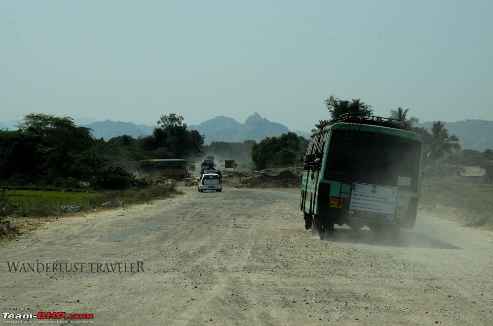
NH66 Tindivanam - Tiruvannamalai Road (Pic Courtesy: Wanderlust Traveler @ TeamBHP


Back breaking bike ride came to a halt at 9:30AM when we were greeted by monuments dotting the outskirts of Gingee town.  Had a feeling of some sort similarity in layout of Hampi and Gingee…further probing proved the initial thought.

Wading through the dusty Gingee town we arrived at the gates of Gingee Fort.  ASI security staff double up as guides here.  It’s better to hire a guide considering the huge area that need to be covered spread over two hills.

Quick facts of the Gingee fort before we start..

The Gingee Fort complex is on three hillocks: Krishnagiri to the north, Rajagiri to the west and Chandrayandurg to the southeast. The three hills together constitute a fort complex, each having a separate and self-contained citadel. The fort walls are 13 km and the three hills are connected by walls enclosing an area of 11 square kilometres. It was built at a height of 800 feet (240 m) and protected by a 80 feet (24 m) wide moat. – Wiki

Massive wall cutting through the road


Timeline…

  •        Jains had dwelt in Gingee from 200 B.C. to 500 A.D
  •       During Chola regime (900 A.D. – 1003 A.D.) a small fort was first built atop the hill.
  •       Under Konar regime (1190 A.D. - 1330 A.D.) the fort was strengthened
  •       For a brief period, fort was with the Hoysalas in first half of 14th century
  •       In 15th century, fort passed on to the Vijayanagara empire and was ruled by the Gingee Nayaks.  Under their regime, Gingee saw massive expansion and was modelled on the lines of Hampi.
  •       Nayaks rule ended with the fort passing on to Bijapur Sultans in 1649 A.D
  •        Bijapur was in possession of the fortress of Gingee till 1677 A.D., when Shivaji, took control over it during the Carnatic expedition. The Marathas greatly strengthened and fortified its defences.
  •       In 1698 fort fell into the hands of Moguls (Aurangazeb) after siege which lasted seven years which was led by Shivaji’s son Rajaram.
  •        It then passed on to Rajput Sawrup Singh – vassal of Aurangazeb in 1700 AD
  •       Then on to his son Raja Desingh who lost the famous battle to the Arcot Nawabs.  The ballets are sung in and around Gingee till date about his bravery.
  •        French took control over the fort in 1750 and then on to the British in 1799.  After that Gingee had been free from the ravages and anarchy of war, but subject to desolation and decay.


I had to put together this roller coaster history of the fort after reading through a dozen portals as the ASI staff are good just to take you around all places.  Only history they know is the folkfore of Raja Desingh which they feed you through the day.


Garrisons all the way up


Fort is under the control of ASI from the year 1921, and are doing a decent job of maintaining the ruins with the available paltry resources.  Fort of such magnitude require far bigger army of men to maintain it to the standard of say the Agra or Fatehpur Sikri forts.

Plan was to cover the hills of Krishnagiri in the first half and Rajagiri being the bigger one was planned for the second half.

Guided tour started with us climbing the Krishnagiri fort which is a easier climb in comparison to the Rajagiri hill.  Steep flight of steps put together with crude stone slabs is all that takes you to the top.  Gingee was planned to a be self-sufficient city which meant it could bear years of enemy siege and natural calamities with ease. 

Cannon post with turntable facility
On the way to the top we came across many granaries, oil wells, caves for collecting rain water.  Watch towers dot the fort wall running across the hill and few cannon launch pads with turn table facility enabling 360 degree coverage amply portray the capabilities what once was “troy of the east”.

Granary

Ghee storage tank

Lakshmi Temple

Flight of steps lead us to the plundered Lakshmi temple bereft of any statues.  Few natural color paintings can be seen on the temple walls.  

Lakshmi Temple


Natural Dye Paintings


Ranganatha Temple

Ranganatha temple  has an elaborate structure with bali peeta and mantapa for deity procession.  Other structures are just in shambles and hardy anything to make out of them in their current state.  Further climb leads to the ornate kalyana mantapa.  

Sacntum - Ranganatha temple

Kalyana Mantapa

Paintings inside Ranganatha temple


Balipeeta


A structure of indo saracenic architecture is seen on the top of the mountain.  It is considered built for the Muslim wife of Desingh.


From the top of the Krishnagiri hill, majestic Rajagiri hill and the place complex ruins can be seen at a distance.  Bracing ourselves of the big climb of the day we made quick descent.
With renewed gusto we started our explorative sojourn of Gingee’s Rajagiri Hills which forms a major part of the fort complex.  

View of the Rajagiri Hill from Krishnagiri Fort


Only sad part of the guided tour that I realized after getting back is that, only story we were fed of Gingee was the that of Raja Desingh.  Absence of informed guides is a bane and they just prove good to help you cover all spots.

Entrance to the Rajagiri Hill Fort

At the entrance of the fort complex, is the Sadatullah Khan mosque.  He was  trusted general of Desingh.  Further down are two ponds Chakkarakulam and Chettikulam.  Being an arid region, such ponds were of yeomen importance.  Fort saw major development during the Nayaks and profile of the place is very similar to Hampi on this note.

Structure - Final rights of Raja Desing were perfomed here

Next to the pond is a big raise structure on which was lit the pyre of Raja Desingh. Desingh is a war hero who continues to live in the hearts of locals who speak of his bravery in local focalfore and street plays.  At the young age of 22 with just an army of 350 horses and 500 men which was not match to the army of Nawab which was 8000 horses and 10,000 men strong.  Mounted on his horse Neelaveni, fought valiantly and attained martyrdom.  Nawab impressed with his valour, arranged for his funeral with state honours.  Desingh’s young wife immolated herself on the pyre, giving credence to the practice of sati.  In appreciation of the supreme sacrifice the Queen, the Nawab ordered for a new town to be built in her name, the present ‘Rani pet'. In the name of their infant son, the Nawab got another town ‘Balajipet' built – which later came to be known as ‘Walajapet'.

Kalyana Mahal tower


Sprawling structures which housed the royal staff


Kalyana Mahal, one of the very few structures that remain intact.  Built during the Vijayanagara rule, it has a square court in its centre with a high tower measuring 27m and was used as living area for the queens.  Sadly it was closed for maintenance and we had to settle with exterior pics.

Darbar

Granite Stair


Next to the Kalyana mahal is the sprawling darbar hall surrounded by the resident quarter of the kings staff.  One interesting structure we came across was the spiral stone stairs which was just one thing out of the world.  Usually such designs are seen in wood and having them made of hard granite speaks of fine architects of the past.

Magazine Storage


Moving ahead, we came across the Magazine storage area.  This was an underground structure beautifully integrated to a crevice in a huge stone mass.  Small openings on the top lead to least exposure for the explosives to heat and moisture.  Men had to be dropped through ropes to get into this underground yard.

Elephant Tank

Huge arch of the Elephant Tank


To the South further, stood a water body by name Elephant tank. Steps are provided in the Southwest corner of the tank so that elephants could climb down and get out easily.  Again different versions of this structure are up in the in air on the actual purpose it was meant for.  Afternoon sun was blazing with the summer having just started, our guide – a retired Army man stood strong to his trait. 

Inside on of the huge Granaries

Granary

Granary with three portions


Next came set of two big granary (one of them is wrongly believed to be a gymnasium though).  Interestingly, guide asked us to climb the footsteps going around the structure and reach the top.  Once back, there he goes bingo! “I was preparing you people for the hard climb of 1,000 steps under the hot sun for next two hours”.  True military istyle!

As we move towards the steps, announces a board that entry further is prohibited after 3PM.  Further enquiry with the guide revealed the fact that, being surrounded by dense forest, animal trouble is something which ASI is wary of.  To ensure that people are made to come down before 6 PM, they stop fort entry.


Difigured sculpture - Venugopalaswamy temple


Monkey trouble started once we started climbing the steps, stick wielding guide ensured they are at bay.  Steady climb atop the hill, we encountered that Venugopalaswamy temple which contains a stone slab depicting a remarkable piece of sculpture cut out in bold relief on the side of a mass of rock. Herein are carved a panel of Lord Krishna playing the flute with his two wives, Rukmani and Satyabhama, and two female figures.


Kamalakanni Amman Temple

 Thankfully flight of steps stop made way to flat plain walk along the vegetation which lead us to the  Kamalakanni Amman shrine.  It is a working temple with a huge stone in the front bearing the image of a buffalo.  Every year buffalos are slaughtered as an offering to the presiding deity. 


Wooden Bridge


Further climb through steep stairs lead us to two cannons and set of granaries.  The fort is surrounded by Muttakadu Forest on one side and steep cliff on the other side providing it a natural defence.  The entrance to the main citadel you encounter deep chasm about 24 feet in width and 60 feet in depth. This chasm has been further artificially deepened. The entrance to the citadel, as we find it to-day, is by means of a wooden bridge thrown over it. 
In all it does prove to be an impregnable fort.  Mughals had a tough time with the Marathas here as any attempts to use Monitor Lizard to climb (Marathas own technique) the walls were thwarted by way of trained eagles which would pull them down. 


Bell Tower cum Flag post on top of the Rajagiri hill

Ranganathaswamy temple
 The final summit after an hour and half of tough climb is a desolate Ranaganatha temple and a bell cum flag mast tower.  The picturesque view you get from the summit is a sight to behold and puts to rest all tiredness accumulated.


View of Venkataramana temple from Rajagiri hill


Spending some time enjoying good wind and the views from the top of the world we had to rush down to the Venkataramana temple situated a km away from the base of the hill.  As we got down, beautiful aerial view of temple mesmerised us. 

Venkataramana Temple


Gopura - Venkataramana temple


This temple was built by Muthialu Nayaka in 1540 A.D. - 1550 A.D.  The temple abounds in gopuras, mandapas and sculptured panels depicting gods and goddesses in scenes from the Hindu epics. The temple seems to have faced hard times during the French occupation (after 1761 A .D.) From this period the temple experienced forms of decay and old archaeological wealth was plundered by subsequent invaders. Locals reveal the fact that, before restoration by ASI, it mound of soil which had engulfed the temple.  In this temple there are also deities of Devi, Aandaal and Narasima.


 There is a well which has crystal clear water and a netwrork of water ways bring in the water from Chettikulam tank into it.  French removed many pillars from this temple and placed them in Pondicherry which can be seen even today.  Recent efforts by Right wing organizations has resulted in the start of worship at the temple after 330 years.  We were asked to sign a register maintained to help them win the case in the court to continue worship.  Such is the sorry state of the Nayak wonder. 


Dwarapalakas


 Huge dwarak palakas with broken nose greet us at the entrance of the sanctum.  Huge wooden board is seen covering up the underground chamber beneath the sanctum meant for exigencies.  Offering our prayers to the lord and some photo shoot, we had to rush a bit to call it a day.  Bad roads back home till Tindivanam were very much in our mind and had to be covered in decent sun light.  Bidding farewell to our guide who had spent the whole day with us, we departed with our hearts and minds full.


Overall Gingee is good weekend spot for Chennaites to explore and history buffs to ponder about.

Few pointers:


  • Gingee is located 156kms from Chennai and is located on the Tindivanam – Tiruvannamalai NH66
  • Being part of an arid region, better to avoid visit in summers as exploration involves hard climb through the day in open sun.
  • No good eat outs are available at Gingee, better to take some packed food
  • Guides are available and can be contacted at the ASI ticket counters
  • Climbing up the Rajagiri fort is prohibited after 3PM
  • Beware of monkeys, they are very good at techniques of scaring humans.


Monday, July 28, 2014

Long walk to freedom - Nelson Mandela


I am the master of my fate, I am captain of my soul. – Madiba

What better than watching his biopic “Long walk to freedom” on this birthday week.
“Long walk to freedom” is a powerful portrayal of Madiba and his fighting spirit for the wellness of the South African society.  “Invictus” potrays him as a leader who inspires a country torn down by separatism into what he calls the rainbow nation.  This biopic is a step back from where Invictus takes off.

A Gist…

Life and times of Mandela from his childhood to his taking over the reins of the country are packed in this movie of over 180mins. Idris Elba has etched the role of Mandela and looks very much the boxer kind Madiba was.
Movie begins with the young smart lawyer Mandel winning cases for the native against the Afrikanas. 

He gets drawn to the political life and becomes a key figure of the African National Congress adopting non violent methods of protest against Apartheid.  Circumstances draw him into an armed struggle against the government and lands him in Jail at the Robben Island.
Madiba sacrificed every bit of his youth and personal life by placing welfare of the society before his family.  Winnie Mandela(Naomie Harris)his life companion stands by him during his violent struggle and imprisonment of 27 years, endures all pain inflicted on her and children by the government.

Hard labor at the Robben Island prison and prolonged separation from his family does not deter the fighting spirit of Mandela.  Upon release he does find Winnie on a different plank of struggle (armed one) and both part ways.  Family parting ways due to ideals of nationalistic struggle are bit hard to digest.
Mandela on his release portrays the best of leadership qualities and preaches reconciliation and abhors hatred towards the Afrikanas.  Movies ends with him getting elected the first native African President of South Africa.

My take…

Justin Chadwick (Director)  has tried his best to fit in the life of times of Madiba in this 180min quick journey.  Felt bit rushed through in many of the scenes, can’t help it – movies have their limitations in case of biopics to be precise.  Have better decided to get hold the Autobiography on which the film is based on.

Idris Elba looks good as the young Mandela, I would still rate Morgan Freeman as the best fit for the “ old man Mandea”.
Overall a nice watch and don’t miss to watch “Invictus” which unfolds the magic of the old man Mandela  - The true leader.

 Best quote I would say in the movie “I have walked a long walk to freedom. It has been a lonely road, and it is not over yet. I know that my country, was not made to be a land of hatred. No one is born hating another person because the color of his skin. People learn to hate. They can be taught to love, for love comes more naturally to the human heart.”


Sunday, June 1, 2014

Trek - Bandaje Arbi Falls


Backpacking through the hinterlands is such an amazing to-do thing.  The people you meet, culture you experience, team bonding that develops - in all its a vibrant experience.  Had been a pretty long time, i had ventured out on a hard core travel stuff.  Mind craving, up came the plan for a two day trek to Bandaje Arbi Falls located in the state of Karnataka.   I had done this trek earlier in the winter 3 years back, now was opportunity to do it in the beginning of the monsoon.


Team: L To R -- Prasanna, Harish, Subbu, Muni, Arun, Muthu

Work started with reading of latest blogs to understand current conditions.  Few new developments had come in, to what i had last time.  Permission from KA Forest department was to carry out the trek was a must.  We got in touch with the concerned official and he obliged.  

This trek mandates the support of a guide as day one is through a thick Shola forest where at times there are no routes due to the overgrowth of vegetation.  We checked with couple of the known guides in the area and were not getting a favorable response.  Sanjay who was suggested by the Forest guard had agreed but with a rider that he would accompany only for a day and would leave us at the Arby falls.  With no better option left, we had to agree to this as day 2 were full of grass lands and navigation is not that difficult.  All set, now it was a six member team that would take up the two day conquest of the W Ghats.

Plan was to start the trek from the Dharmasthala side and exit via the Hornadu side.  Tickets were booked in KSRTC accordingly from Bangalore.

Details of the Trek:
  • Trek to Bandaje Arbi Falls
  • Camp over night atop Arbi Falls
  • Trek from Arbi Falls to Ballalarayana Durga and reach Sunkasale

Day 0:

Five of us started off from Chennai (Muni based at Blr)  in my Figgy and plan was to reach Muni’s house in time to catch the bus to Dharmasthala by 10:20 PM at Bangalore.  Tight schedule and location of Muni’s house at Blr forced us to take the Chittor-Kolar route which is a two lane filled with purest of Morons on the road.  Meanwhile Muni had collected the tents from BMC and we reached just in time to board the bus at Majestic. 

Chennai to Bangalore by Figgy


Day 1:

We reached Dharmasthala via Hassan – Sakleshpur an hour late than the scheduled time by 6:30.  Finishing off our morning chores, we hired a Jeep to Bandaje with a pit stop at Ujjire.  Finished our b’fast with Mangalore buns and packed some for the lunch. 


At Dharmasthala bus station


At Ujjire

 Jeep guy dropped us at the estate house of Narayana Gowda which is the start point of the trek.  Raj – the forest guide arrived once we informed him and we finished the formalities with a request letter and paid the trek fee.  Sanjay who was to be our guide arrived and informed us of the leeches which he felt might trouble us.  We got some snuff powder and applied it on to the socks and shoes.  Little did we realize at that time that no power on earth is going to save us from leech bites that day.

Note: Narayana Gowda who used to help trekkers by providing guides is no more.  His son Kishore can be contacted for hiring of guides.


Narayana Gowdar Mane, Starting point of the trek
Sanjay - Guide

All set and with do and dont's dished out by the Forest Guard, we started the trek slowly through the plantations by 9:50.  Plantations slowly gave way to thick shola forest, rains had just receded two days back and humidity level inside the forest was extremely high.  Profuse sweating took toll on us making us take small breaks and the ascend was becoming tougher.  Now started the encounter with the 2 inch predator which kept us on our toes till late noon.


Crossing Streams


Last of habitaion


There we need to go!

Decked up for the ascent


Every face spells out the state! 

Gasping stops

Any point in time four to five leaches were climbing on to us and if we stopped any where, it became tens of them attacking in all directions.  We stopped couple of seconds here and there pulling them down, still everyone was bitten badly.  Reached the stream crossing by 12 Noon,   we put down all luggage and checked every bit of us to pull out the leeches.  Snuff powder was snuffed away by leaches of Bandaje and they were happily doing their duty deep inside our shoes. 


Red terror caused by predator
Being the last big water body before the falls, we had our lunch here and filled our bottles.  Atmosphere was very serene with crystal clear water which was flowing down from the Arbi falls.  Hour spent relaxing, we moved further and ascend became even tougher.  Leech menace continued and ensured that we run, literally run for our lives. 


At about 15:00 we reached the edge of the forest, where starts the grass lands and the respite of a leech-less land.  Beauty of the place just hits you the moment you step out of the forest as you can see endless grasslands interspersed with Shola forests.  We took some rest before we proceeded on to the final leg of the day.  


Six - O- people


Mid way into the grasslands, we came across a small pool of water flowing down the ridge, it was a spring.  Filling our bottles, we proceeded further.  Spring water is the purest form of water you can ever have.


Spring water


30 mins into the trek, we could spot the Arbi falls dropping 200 ft down the cliff.  Sanjay our guide wanted to return to his village and we bid adieu to him thanking for all help.


Arbi Falls
Steady trek for another hour lead to us to a peak.  Other side of the peak lies a valley through which gushes the waters, thundering  down to become the Arbi falls.  The approach to this valley is bit scary with a 200ft gorge having a descent of 70 degrees.  Any small slip could cost us dear.  With great caution we reached the water body and crossed over to the camping site by 17:00. 


We were the only souls this time in the camping area and we chose two tenting spots next to each other.  Light was fading and took us an hour to pitch both the tents in place and also lit the camp fire.


Everyone was exhausted to the core and Muni had just spotted a Bison family on the next hill.  Guys could hardly eat and we just wanted to get into the tents and call it a day.  Scary noises of insects and birds kept few awake in the night. 


Tent ready !!


Night spent, we got up early by 5:30.  Gushing waters of the stream and rays from the rising sun made the atmosphere very relaxing.  We had good time taking a dip in the ice cold waters of the stream.  It was real fun listening the next day the horrific thoughts the guys had - fear  of a lone elephant tramping us down, heavy thunder showers hitting us and what not.  Guys even had leeches biting them in their dreams.  What made matters worse was the fact that, we were the only ones camping that day in the middle of the forest and were exposed to danger from unexpected quarters without any support.


Water gushing down to form the Arbi falls


Winding up the tent and packing our bags, filling the water bottles we left for the next destination - Ballalarayana Durga by 9:30.  Guide, the day prior had given us basic directions to the fort.  Following his directions we crossed two mountains only to find no sight of the fort.  For couple of minutes, feeling of being lost crept into everyone.  Some close inspection of the trail and sense of direction I could figure out that we are on the right path and followed a trail leading us to other side of the next hill.  Hurray, I could spot the Fort at a distance some 4-5 hills down.  Having done the trek earlier, I could make out the fort from a distance. 


Making matters worse now was the fact that clouds were all over us and visibility dropped to 20 feet.  Relying on the trail we kept progressing on the terrain, day 2 of this trek is kind of manageable as steep ascents are small patches.  


Clouds playing hide n seek

Visibility - where !


Fort at a distance

Path goes on and on


Bison family 

30 mins down the trail, I spotted a bison group on the next hill.  Sound of my footsteps had captured their attention and the group was staring at me.  Rest of the group was as at a distance and it was me and Muthu facing the beasts.  We decided to run away from that place before the bisons even decide to charge and to our astonishment, they ran helter skelter into the forest.  Relieved, we continued our journey only to see another group of animals which looked like the bison on the hill next to the fort.  We had exhausted all water we had, making matters worse was the fact that, next source of water was 4 hours away. 


Ballalarayana Durga

We reached the fort by 12:30 and to our surprise found a samaritan Lokappa who resides in the fort rearing cattle.  Those animal we had seen on the next hill were indeed his cows and he had 100 of them.  He provided us with much needed water and shared stories of leopard taking away his cattle and of the visitors to his place elephants, bears and bisons.  We had a pretty nice chat and he was asking us of our trip and whereabouts.  The fort ramifications were running on the next two hills and it was pretty curious a thing of why such a fort in the first place was built in the midst of a dense forest.

Lokappa and his humble house


Fortification running across the hill


About the fort:

 The Ballalarayana Durga fort was constructed by the wife of Veera Ballala-l who was the king of the Hoysala Empire in the 12th century. The Hoysalas were known to be patrons of art and architecture and built several temples and a few forts during their rule. The Ballalarayana fort was built in the Karnata Dravida style of architecture, the architectural style that was popular in the Hoysala Empire during their rule. Situated atop a hill that is 1509 metres high, the fort overlooks the town of Sunkasaale. The fort has lost its glory and stands as a distant reminder of its beautiful past.  

We asked Lokappa for further directions as clouds around the fort were giving us zero visibility of the valley below.  With clouds clearing now and then, he pointed us to the mud road in the plains and the Battar mane where we can have some rest and food.  As things were not so promising, we requested him to accompany us till a distance down the hill.  The fort is the final point atop the hill and next part of the trek involves rapid descent down the hill partly through grass lands and thick foliage.  He accompanied us for next one hour till a point where we could help ourselves.  We thanked this angel of the day and proceeded down the hill till we reached the jeep track and then the thar road.  

Border line, summit reached
By about 15:00 we reached the house of Battar, we were dead hungry by the time.  Muni the only Kannda speaker conveyed our condition to the wife of Battar.  Battar was away and the old lady proved the next angel of the day.  Not only did she allow us take rest in their property, she served us with a preparation by name “Halasina Hannina Kadubu”.  Basically a mixture of jack fruit and rice, grind-ed and steam cooked – a South Canara delicacy.  Kadubu tasted divine and jack fruit was from the trees in the very same property.  The old lady felt very bad that she could not serve us with proper food and asked us to relax for some time.  We got the directions for Sunkasale from her and proceeded on to catch an auto.  

Halasina Hannina Kadubu


We were there couple of hour ago..
Reaching Sunkasale in another 30mins, we had some quick bite at a small hotel there and caught the bus to Horanadu.  Next on the agenda was the visit to the Annaporneswari temple at Horanadu.  30kms journey winding through the thick forest and coffee plantations lead us to Horanadu, situated on the banks of river Bhadra.  Temple authorities have built a very good choultry next to the temple where we booked ourselves a room to freshen up.  The rooms were so clean and with running water.  Karnataka temples stand apart in providing good facilities to the devotees which I often find lacking in TN. 


Annapoorneshwari temple at Horanadu.
 (Courtesy:Temple Portal)
Being a working day, temple was sparsely crowded, we had a nice darshan and proceeded to the Annadana hall.  More than Annadana, it is considered the prasada of goddess Annapoorana.  Finishing the Annadana, we packed our bags for the bus to Bangalore at 21:15.

Bus dropped us of at Bangalore at 5 AM and we proceeded on to Muni’s house.  Took some rest and had a great B’fast at Muni’s place and we bid adieu to his family and left for our destinations. 

 It was only three of us returning to Chennai we took the relaxed Krishnagiri route to back home.


Few Pointers:

  • Dharmasthala is 300kms from Bangalore.  KSRTC has services of all classes on this sector.
  • Driving down would not make sense as trek ends on the other side of the ghats.  If driver is doing the job, he can be asked to be at Sunkasale the next day evening.
  • Dharmasthala to Bandaje village is about 20kms.  B’fast and food parcel can be taken at Ujjire which is the last place with basic facilities.  Jeep guys charge anywhere between 600 to 700 INR for this leg
  • KA Forest permission is mandatory.  Prior phone permission helps.  Charges 75 + 200 INR per head
  • Guide for one day Rs 950 till Arbi falls
  • Time to Trek: 4-6 hrs from Gowdara mane to Bandajje Falls. 2-3 hrs from Bandajje Falls to Fort. 1-1.5 hr down to Durgadahalli
  • Distance: 8-9 kms from Gowdara mane to Bandajje Falls. 4 - 4.5 kms from Bandajje Falls to Fort. 3 kms down to Durgadahalli. Total ~15-17 kms
  • Autos are available from Durgahalli to Sunkasale, distance of about 10kms.  If energy levels permit, can be done on foot.
  • Sunkasale to Horanadu buses every 20 mins, distance of 30kms
  • Horanadu is 319kms from Bangalore.  KSRTC has SKS and Rajahamsa services plying on this route.
  • Horanadu has a huge temple choultry with clean rooms with running water.  120 INR per day room rent
  • Horanadu is part of Chickmagalur district famous for coffee plantations. Coffee can be purchased from shops here.
  • Contact Details for the trek:
    • Forest Officer: 99013 46952
    • Guide - Sanjay: 97408 83257
    • Kishore Gowda(Landlord Bandaje) : 99019 39829